I have not ever published videos on Blogger so I don't know what this will be like, but there should be three videos here.
This movie is the Franz Josef Glacier letting go of some of it's ice from about 100 yards away.
This is a waterfall near Lake ???? on the North Island.
Listen to the penguin call...
the trick is to see if you can see the little fella that is yellin'.
Wednesday, April 29, 2009
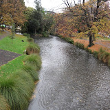
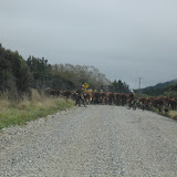
On the road to Christchurch
View Larger Map
What is this, rain?
We have been so fortunate in our adventure to have had almost no rain, even though the forecasts have said there would be rain. Well, it caught up with us today. So, we pretty much just drove to Christchurch straight away, there were no real sites along the way and so we'll head in to the city to see what it has to offer. We staying at a hostel in the city center. We have purchased our ferry ticket for the return to the North Island, oh no, this means our adventure here in New Zealand is coming to a end:(
Holly spent the afternoon roaming the town center and visiting the art center, which we visited this evening, it is a really nice city it seems, but we won't spend too much time here as we need to head north.
 |
| Christchurch |
If anyone wants a great outdoor adventure and you have the time (and $), you have to come here, it is just too beautiful and peaceful and everyone is so friendly and helpful.
Oamaru
View Larger Map
We were glad to be on the road again after Dunedin and we are heading north along the east coast towards Chirstchurch, but we will break this up into several short travel days.
The first diversion was to Shag Point, to view some seals, we were too early for the penguin viewing. Then it was on up road to see the Moeraki Boulders, these are large geoids that Holly had seen on the cover of her guide book and was very excited to go and see them. They were pretty cool.
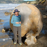 |
| Moeraki Boulders |
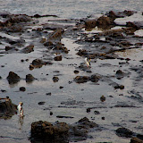
Our night was spent in an old hotel that is now a hostel in the town of Oamaru, which of course had more penguin viewing. We got checked in and were off to the beach to view the Yellow-Eyed Penguins again, they also had Blue Penguins nesting near, but it cost $20 to see them, so we go for the free stuff. It was amazing to see how high these little things would nest on the cliff sides, there some pretty good rock climbers! Later that night from our room we good hear the Blue Penguins calling, we were told that they would come into the parking lot at night (the hostel is very close to the ocean), so Holly had to try and see them, but she did not have any luck except for this exceptional large grey penguin;)
 |
| Oamura Penguins |
Dunedin & Otago Peninsula
View Larger Map
After we left the Curio Bay area we knew where there was gas, it was about a 1/4 of a tank away and we had about a 1/4 of a tank, but there were still some things we needed to see along the way.
The Cathedral Caves were these two large, not too deep caves that have been cut into the seashore cliffs. They are only accessible at low tide and our timing was perfect, so we had to go. It was a short 20 minute hike down to the shore, of course this means a 30 minute hike back up, but it was worth it to see this site.
 |
| Cathedral Caves |
Then we had to stop and see a couple of different waterfalls that were short hikes off the road. It was fun to run into many of the same people along the way to many of these spots and chat with them about what they had seen and done and compare notes and learned what we hadn't seen.
Then we headed to Nugget Point to have a look at another lighthouse and take a 30 minutes hike and a swim down the coast from the lighthouse, it wasn't really a swim, the water was colder here than it has been any where else.
 |
| Nugget Point |
We made it to Papatowai just after the gas light came on, yeah! Filled up the car and then drove on to Dunedin, we still are not pronouncing this cities name correctly.
The campground that we stayed in was out on the Otago Peninsula, close to the Royal Albatross colony. Unfortunately, everything around Dunedin was more commercialized that what we have experienced in the other parts of NZ, including getting a view of the Albatross and finding a good hike was not too easy. The most entertaining thing was watching couple, as we relaxed at a seaside joint, scooping up gravel from the roadside (they were putting on new gravel on the road) and hauling it away in buckets. They got several car loads, it looked to us like this was her idea and her husband was feeling guilty about this crime they were committing, we had fun watching them.
 |
| Otago Peninsula |
Porpoise Bay
View Larger Map
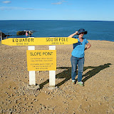
We left Riverton behind and headed towards the southern most point on the South Island, Slope Point. As usual we were not certain where we were camping but read about a place on Curio Bay (close to Porpoise Bay) that we run by a old surfer and that was very near a Yellow-Eyed Penguin nest.
The first stopped should have been Invercargill to get some gas, but I choose not to do this and later after we got on to the back roads towards Curio Bay this really started to stress me out, because none of the small communities that we went through had gas. Holly's guide book was written as if we were going the other direction and so she has been reading about the things to do in reverse order, when she read the beginning it stated that the gas supplies are rare in this region, yikes!
 |
| Slope Point |
Anyway, we were committed to going forward, so on to Slope Point for a short hike and photo op at the southern most point, just below the 45th parallel. Then back in the car and on to Curio Bay, where we camped for the night. The camp grounds were unique, in that it was on the coast which is very, very winding, but the campsites are cut into a NZ flax field, these provided for great wind blocks, but also allowed places for our friends the sand flies to hang out, they were thicker here than any where and so DEET was in order.
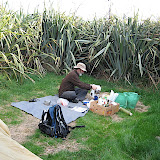 |
| Curio Bay Camp |
The camp was about 400 meters from the penguin nest, they come in to nest each night at sundown, so we walked over there and watched as about 7 came in to nest. These creatures and very shy and will not come in to nest & feed their young it they feel threatened at all. Well, this was a problem since the signage at the look out stated that you could be as close a two car lengths, but what Holly had read was that you should not be on the beach at all and she was right. Holly had to ask a couple that was on the beach to come up and let the penguins get to their nest, which the folks did and the little creatures did make their way up the hill to their nests, yea! I have some video footage that I am trying to extract the penguins calls from, no luck yet, I'm lame sometimes.
The nesting area is also where some remnants of a petrified forest exists.
 |
| Curio Bay Penguins |
On the road to Riverton
Most of this adventure has been fairly adhoc, we have a general idea of the direction we are going to head, but Holly reads as I drive about things to see & do along the way.
View Larger Map
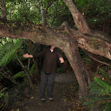
We left our Eglington campsite & the Fiordlands behind and headed back to Te Anue to restock and head south. We thought that we might camp at Lake Monowai, but we just stopped there for a short hike and then went to on to hike up Mt. Burns.
Mt. Burns was a great 1 1/2 hour hike through woods that were covered with white-hanging moss and got us up above the tree line and provided for a spectacular view of the southern Fiordlands.
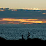
After a quick peanut butter & jelly sandwich is was on towards the southern tip of the South Island. We thought we would spend the night in Tuarapere, but once we got there it was unimpressive (hard to believe), so we decided to go on to Riverton. Riverton turned out to be a great choice, a small little seaside village, and we stayed at the Globe Hotel. The Globe was a backpackers hotel, as most of the places we have stayed are (if we are not camping), that served up a great pizza, Bruce's Burner, was my favorite. We liked this village enough that we stayed for two nights. Friday night there was open mike at the bar at the Globe and the music was the best we have heard while we have been here and it drew a large crowd.
The next day was NZ Anzac Day, their Memorial Day. As I headed out to get some sunrise photos, there was a small parade led by bagpipers coming down the main street. After this I headed out and got some nice shots of the sunrise. Later at about 10 am, there was a larger parade that we attended, with many more bagpipers and much larger crowd than the sunrise parade.
Later that day we took a hike out through a preserve that took us to the ocean, we are now on the South Pacific, no longer the Tasmen Sea. Holly is a shell hunting freak and she was in hog heaven on this beach, She has quiet the treasure trove of shells not to bring back with her. Then it was back for more pizza and checking out the few stores/galleries that were open.
View Larger Map
We left our Eglington campsite & the Fiordlands behind and headed back to Te Anue to restock and head south. We thought that we might camp at Lake Monowai, but we just stopped there for a short hike and then went to on to hike up Mt. Burns.
Mt. Burns was a great 1 1/2 hour hike through woods that were covered with white-hanging moss and got us up above the tree line and provided for a spectacular view of the southern Fiordlands.
 |
| Mt. Burns |
After a quick peanut butter & jelly sandwich is was on towards the southern tip of the South Island. We thought we would spend the night in Tuarapere, but once we got there it was unimpressive (hard to believe), so we decided to go on to Riverton. Riverton turned out to be a great choice, a small little seaside village, and we stayed at the Globe Hotel. The Globe was a backpackers hotel, as most of the places we have stayed are (if we are not camping), that served up a great pizza, Bruce's Burner, was my favorite. We liked this village enough that we stayed for two nights. Friday night there was open mike at the bar at the Globe and the music was the best we have heard while we have been here and it drew a large crowd.
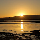 |
| Riverton Sun |
The next day was NZ Anzac Day, their Memorial Day. As I headed out to get some sunrise photos, there was a small parade led by bagpipers coming down the main street. After this I headed out and got some nice shots of the sunrise. Later at about 10 am, there was a larger parade that we attended, with many more bagpipers and much larger crowd than the sunrise parade.
 |
| Riverton Anzac Parade |
Later that day we took a hike out through a preserve that took us to the ocean, we are now on the South Pacific, no longer the Tasmen Sea. Holly is a shell hunting freak and she was in hog heaven on this beach, She has quiet the treasure trove of shells not to bring back with her. Then it was back for more pizza and checking out the few stores/galleries that were open.
 |
| Riverton Walk |
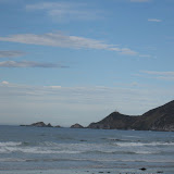
Milford Sound & Humbolt Falls
After the Divide we continued our day, driving to Milford Sound, which is a big tourist attraction. We had to go through a 1/4 Mile tunnel that was one lane, cut through granite, there are stop lights that signal when it is time for you to drive through. Then it's down a twisty road to Milford Sound. We spend just a short time here, since we were not interested in taking a boat out into the sound, which is what most folks do, to get a view of sound from the sea.
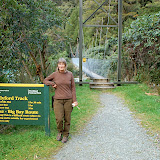
On the way back to camp we took a road out to Hollyford Track, one of the many multi-day tramps. This road, like many we have been on, is a gravel road, that followed a creek, it look more like a stream than a creek to me, with big boulders in the stream. From our visit to Franz Josef & Fox Glaciers, Holly had told me how you can tell it the water comes from a glacier, it is a light gray, and many of the streams were from glaciers.
At the end of the road, we did a 30 minute hike up to Humbolt Falls, a tall spectacular 3-tier falls. Then, it was back to camp for the evening meal, stoved top veggies, yum!
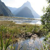 |
| Milford Sound |
On the way back to camp we took a road out to Hollyford Track, one of the many multi-day tramps. This road, like many we have been on, is a gravel road, that followed a creek, it look more like a stream than a creek to me, with big boulders in the stream. From our visit to Franz Josef & Fox Glaciers, Holly had told me how you can tell it the water comes from a glacier, it is a light gray, and many of the streams were from glaciers.
At the end of the road, we did a 30 minute hike up to Humbolt Falls, a tall spectacular 3-tier falls. Then, it was back to camp for the evening meal, stoved top veggies, yum!
 |
| Humbolt Falls |
Subscribe to:
Comments (Atom)