I have not ever published videos on Blogger so I don't know what this will be like, but there should be three videos here.
This movie is the Franz Josef Glacier letting go of some of it's ice from about 100 yards away.
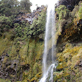
This is a waterfall near Lake ???? on the North Island.
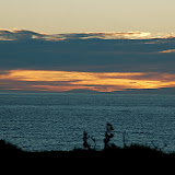
Listen to the penguin call...
the trick is to see if you can see the little fella that is yellin'.
Wednesday, April 29, 2009
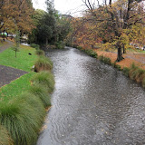
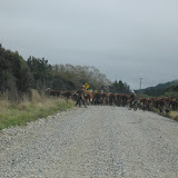
On the road to Christchurch
View Larger Map
What is this, rain?
We have been so fortunate in our adventure to have had almost no rain, even though the forecasts have said there would be rain. Well, it caught up with us today. So, we pretty much just drove to Christchurch straight away, there were no real sites along the way and so we'll head in to the city to see what it has to offer. We staying at a hostel in the city center. We have purchased our ferry ticket for the return to the North Island, oh no, this means our adventure here in New Zealand is coming to a end:(
Holly spent the afternoon roaming the town center and visiting the art center, which we visited this evening, it is a really nice city it seems, but we won't spend too much time here as we need to head north.
 |
| Christchurch |
If anyone wants a great outdoor adventure and you have the time (and $), you have to come here, it is just too beautiful and peaceful and everyone is so friendly and helpful.
Oamaru
View Larger Map
We were glad to be on the road again after Dunedin and we are heading north along the east coast towards Chirstchurch, but we will break this up into several short travel days.
The first diversion was to Shag Point, to view some seals, we were too early for the penguin viewing. Then it was on up road to see the Moeraki Boulders, these are large geoids that Holly had seen on the cover of her guide book and was very excited to go and see them. They were pretty cool.
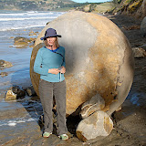 |
| Moeraki Boulders |
Our night was spent in an old hotel that is now a hostel in the town of Oamaru, which of course had more penguin viewing. We got checked in and were off to the beach to view the Yellow-Eyed Penguins again, they also had Blue Penguins nesting near, but it cost $20 to see them, so we go for the free stuff. It was amazing to see how high these little things would nest on the cliff sides, there some pretty good rock climbers! Later that night from our room we good hear the Blue Penguins calling, we were told that they would come into the parking lot at night (the hostel is very close to the ocean), so Holly had to try and see them, but she did not have any luck except for this exceptional large grey penguin;)
 |
| Oamura Penguins |
Dunedin & Otago Peninsula
View Larger Map
After we left the Curio Bay area we knew where there was gas, it was about a 1/4 of a tank away and we had about a 1/4 of a tank, but there were still some things we needed to see along the way.
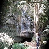
The Cathedral Caves were these two large, not too deep caves that have been cut into the seashore cliffs. They are only accessible at low tide and our timing was perfect, so we had to go. It was a short 20 minute hike down to the shore, of course this means a 30 minute hike back up, but it was worth it to see this site.
 |
| Cathedral Caves |
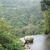
Then we had to stop and see a couple of different waterfalls that were short hikes off the road. It was fun to run into many of the same people along the way to many of these spots and chat with them about what they had seen and done and compare notes and learned what we hadn't seen.
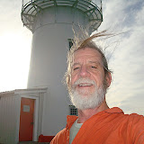
Then we headed to Nugget Point to have a look at another lighthouse and take a 30 minutes hike and a swim down the coast from the lighthouse, it wasn't really a swim, the water was colder here than it has been any where else.
 |
| Nugget Point |
We made it to Papatowai just after the gas light came on, yeah! Filled up the car and then drove on to Dunedin, we still are not pronouncing this cities name correctly.
The campground that we stayed in was out on the Otago Peninsula, close to the Royal Albatross colony. Unfortunately, everything around Dunedin was more commercialized that what we have experienced in the other parts of NZ, including getting a view of the Albatross and finding a good hike was not too easy. The most entertaining thing was watching couple, as we relaxed at a seaside joint, scooping up gravel from the roadside (they were putting on new gravel on the road) and hauling it away in buckets. They got several car loads, it looked to us like this was her idea and her husband was feeling guilty about this crime they were committing, we had fun watching them.
 |
| Otago Peninsula |
Porpoise Bay
View Larger Map
We left Riverton behind and headed towards the southern most point on the South Island, Slope Point. As usual we were not certain where we were camping but read about a place on Curio Bay (close to Porpoise Bay) that we run by a old surfer and that was very near a Yellow-Eyed Penguin nest.
The first stopped should have been Invercargill to get some gas, but I choose not to do this and later after we got on to the back roads towards Curio Bay this really started to stress me out, because none of the small communities that we went through had gas. Holly's guide book was written as if we were going the other direction and so she has been reading about the things to do in reverse order, when she read the beginning it stated that the gas supplies are rare in this region, yikes!
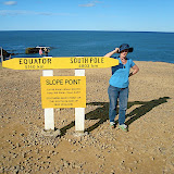 |
| Slope Point |
Anyway, we were committed to going forward, so on to Slope Point for a short hike and photo op at the southern most point, just below the 45th parallel. Then back in the car and on to Curio Bay, where we camped for the night. The camp grounds were unique, in that it was on the coast which is very, very winding, but the campsites are cut into a NZ flax field, these provided for great wind blocks, but also allowed places for our friends the sand flies to hang out, they were thicker here than any where and so DEET was in order.
 |
| Curio Bay Camp |
The camp was about 400 meters from the penguin nest, they come in to nest each night at sundown, so we walked over there and watched as about 7 came in to nest. These creatures and very shy and will not come in to nest & feed their young it they feel threatened at all. Well, this was a problem since the signage at the look out stated that you could be as close a two car lengths, but what Holly had read was that you should not be on the beach at all and she was right. Holly had to ask a couple that was on the beach to come up and let the penguins get to their nest, which the folks did and the little creatures did make their way up the hill to their nests, yea! I have some video footage that I am trying to extract the penguins calls from, no luck yet, I'm lame sometimes.
The nesting area is also where some remnants of a petrified forest exists.
 |
| Curio Bay Penguins |
On the road to Riverton
Most of this adventure has been fairly adhoc, we have a general idea of the direction we are going to head, but Holly reads as I drive about things to see & do along the way.
View Larger Map
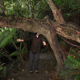
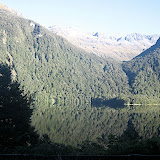
We left our Eglington campsite & the Fiordlands behind and headed back to Te Anue to restock and head south. We thought that we might camp at Lake Monowai, but we just stopped there for a short hike and then went to on to hike up Mt. Burns.
Mt. Burns was a great 1 1/2 hour hike through woods that were covered with white-hanging moss and got us up above the tree line and provided for a spectacular view of the southern Fiordlands.
After a quick peanut butter & jelly sandwich is was on towards the southern tip of the South Island. We thought we would spend the night in Tuarapere, but once we got there it was unimpressive (hard to believe), so we decided to go on to Riverton. Riverton turned out to be a great choice, a small little seaside village, and we stayed at the Globe Hotel. The Globe was a backpackers hotel, as most of the places we have stayed are (if we are not camping), that served up a great pizza, Bruce's Burner, was my favorite. We liked this village enough that we stayed for two nights. Friday night there was open mike at the bar at the Globe and the music was the best we have heard while we have been here and it drew a large crowd.
The next day was NZ Anzac Day, their Memorial Day. As I headed out to get some sunrise photos, there was a small parade led by bagpipers coming down the main street. After this I headed out and got some nice shots of the sunrise. Later at about 10 am, there was a larger parade that we attended, with many more bagpipers and much larger crowd than the sunrise parade.
Later that day we took a hike out through a preserve that took us to the ocean, we are now on the South Pacific, no longer the Tasmen Sea. Holly is a shell hunting freak and she was in hog heaven on this beach, She has quiet the treasure trove of shells not to bring back with her. Then it was back for more pizza and checking out the few stores/galleries that were open.
View Larger Map
We left our Eglington campsite & the Fiordlands behind and headed back to Te Anue to restock and head south. We thought that we might camp at Lake Monowai, but we just stopped there for a short hike and then went to on to hike up Mt. Burns.
Mt. Burns was a great 1 1/2 hour hike through woods that were covered with white-hanging moss and got us up above the tree line and provided for a spectacular view of the southern Fiordlands.
 |
| Mt. Burns |
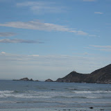
After a quick peanut butter & jelly sandwich is was on towards the southern tip of the South Island. We thought we would spend the night in Tuarapere, but once we got there it was unimpressive (hard to believe), so we decided to go on to Riverton. Riverton turned out to be a great choice, a small little seaside village, and we stayed at the Globe Hotel. The Globe was a backpackers hotel, as most of the places we have stayed are (if we are not camping), that served up a great pizza, Bruce's Burner, was my favorite. We liked this village enough that we stayed for two nights. Friday night there was open mike at the bar at the Globe and the music was the best we have heard while we have been here and it drew a large crowd.
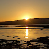 |
| Riverton Sun |
The next day was NZ Anzac Day, their Memorial Day. As I headed out to get some sunrise photos, there was a small parade led by bagpipers coming down the main street. After this I headed out and got some nice shots of the sunrise. Later at about 10 am, there was a larger parade that we attended, with many more bagpipers and much larger crowd than the sunrise parade.
 |
| Riverton Anzac Parade |
Later that day we took a hike out through a preserve that took us to the ocean, we are now on the South Pacific, no longer the Tasmen Sea. Holly is a shell hunting freak and she was in hog heaven on this beach, She has quiet the treasure trove of shells not to bring back with her. Then it was back for more pizza and checking out the few stores/galleries that were open.
 |
| Riverton Walk |
Milford Sound & Humbolt Falls
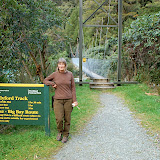
After the Divide we continued our day, driving to Milford Sound, which is a big tourist attraction. We had to go through a 1/4 Mile tunnel that was one lane, cut through granite, there are stop lights that signal when it is time for you to drive through. Then it's down a twisty road to Milford Sound. We spend just a short time here, since we were not interested in taking a boat out into the sound, which is what most folks do, to get a view of sound from the sea.
On the way back to camp we took a road out to Hollyford Track, one of the many multi-day tramps. This road, like many we have been on, is a gravel road, that followed a creek, it look more like a stream than a creek to me, with big boulders in the stream. From our visit to Franz Josef & Fox Glaciers, Holly had told me how you can tell it the water comes from a glacier, it is a light gray, and many of the streams were from glaciers.
At the end of the road, we did a 30 minute hike up to Humbolt Falls, a tall spectacular 3-tier falls. Then, it was back to camp for the evening meal, stoved top veggies, yum!
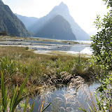 |
| Milford Sound |
On the way back to camp we took a road out to Hollyford Track, one of the many multi-day tramps. This road, like many we have been on, is a gravel road, that followed a creek, it look more like a stream than a creek to me, with big boulders in the stream. From our visit to Franz Josef & Fox Glaciers, Holly had told me how you can tell it the water comes from a glacier, it is a light gray, and many of the streams were from glaciers.
At the end of the road, we did a 30 minute hike up to Humbolt Falls, a tall spectacular 3-tier falls. Then, it was back to camp for the evening meal, stoved top veggies, yum!
 |
| Humbolt Falls |
Eglington Camp
View Larger Map
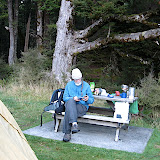
We left Arrowtown and headed into the Fiordlands, which is the area where there are many multi-day tramps and for us great day hikes. The road between Arrrowtown and the DOC (Department of Conservation) campsite, Eglington, an easy 2 1/2 hour drive through great scenery. In NZ there each community has well marked information centers and there are often DOC offices where you can get detailed information about the tramps and hikes in the area. We stopped in Te Anue at the DOC office, got the weather report, mostly clear and cool for the two days that we were going to be in the Milford Sound area. We have been keeping about two nights worth of food with us for camping, plus peanut butter and jelly sandwiches for midday meals, so we stocked up with veggies, rice, and some minute steaks and headed out.
We did not know which campsite we were actually going to stay at, but both Holly & I like our privacy and we found a campsite that supposed to have two campsites at it but we spread out and no one came in to claim the second one, there was only one fireplace and table which we occupied. There was a river about 100 yards away, after the sunset the river produce a nice fog that would come into camp, kind of a creepy, cool effect. The stars were brilliant and we have not become experts at seeing the Southern Cross and Orion (which is upside down compared to the how we see it in the States).
Sand Flies are vicious little things with a bite that sticks with you for several days, itching up a storm. We first ran in to them in Totaranui, but they were here as well. The Maori legend states that when one of the Maori gods had created the Fiordlands the goddess of the afterlife created Sand Flies so that people would not want to live for ever in the Fiordlands.
 |
| Going to Milford Sound |
The next day we drove up to "the Divide", which is like the Continental Divide in the States, this one is produced from the uplift between the Pacific tectonic plate and the Indian Plate. There was a 3 1/2 hour hike from the car park to the Key Summit. The Key Summit has spectacular views and it got it's name since there are three rivers that start here, one going to the West coast, another going to the South coast, and a third going to the East coast. The hike was nothing but up, up, up. At the top was a 40 minute wilderness loop that Holly walked entirely, I had hiked down to Lake Howden Hut and then back up to the wilderness loop, this additional hike really wiped me out, but we made it down, down, down without any problems.
 |
| Milford Sound - The Divide |
Tuesday, April 28, 2009
What do I do now?
I feel like I am so far behind in my posts that I will never catch up. We are currently in Oamaru, just north of Dunedin on the South Island, Dunedin was our first negative experience and that was just because we could not find any free adventures to take, well not as many as we thought we should be able to do. For instance, we did not pay $15/each to see the Royal Albatross and after we talked with a couple who knew about the tour we were glad we did not pay for it. But, I am getting ahead of myself.
FYI, there always seems to be a problem with one of the applications, not so much the application but issues due to connectivity to the applications which are located on some server on the net somewhere in the network cloud. I use Blogger (obviously) which sometimes is slow and gets confused when it cannot connect to various servers, I use Picassa for my photo album sometimes I am not allowed to upload images by some of the service providers (bandwidth concerns on their part, maybe?) they don't want me to consume all their existing bandwidth (kinda ridiculous), and Google Maps. Today it seems to be Google Maps with the connectivity problems, and Blogger a little. So, it is difficult to let you see all that I would like to show you about the places we've been.
Anyway, I need to catch you folks up on the places we have been since Franz Josef & Fox Glaciers; we careened down the west coast to Haast where we turned inland because we had to go around Mt. Aspiring to get to the Fiordlands; yeah, yeah, gorgeous winding roads thru the Southern Alps, rivers below, forest to the sides, beautiful blue skies above, bla, bla, bla;) The scenery and weather has just been spectacular every where we have gone, we have been really lucky with the weather, we keep saying to each other that we should be paid for bringing the good weather with us as we traveled through NZ. All the natural wonders that we have seen, at times we are starting to take it for granted, which is too bad, it is so beautiful in this land. They have a tremendous sense here that they must live with the ecology, not man-handle the ecology, so they have created vast land reserves and national parks.
We spent the night in a cute little village, Arrowtown, not too far north of Queenstown, as we headed for the Fiordlands. This was the last drive (with the possible exception of Wellington to Auckland, when we need to catch our flight) that we will put the hammer down like this and drive for such a long time without a great hike along the way. Arrowtown, was a product of the Gold Rush in NZ during the mid-1800's, this town had a significant Chinese population that migrated for mining. The town has created a park out of the area where the Chinese population was segregated to. The town now seems to be a tourist destination (like quiet of few NZ towns/villages), our accommodations were at a Holiday Park, about 10 blocks from the town center, they were in the midst of a fall festival which had the community buzzing. So the pictures are primarily from the park that had the Chinese artifacts on display.
Well, time to go on down the road, we haven't figured out where yet, which has been our typical modus operandi. But, I will eventually write about, Milford Sound, the Divide in Milford Sound, Humbolt Falls, Mt. Burns, Riverton (our favorite village), Slope Point, Curio Point & the Yellow-Eyed Penguins, Cathedral Caves, Nugget Point, disappointing Dunedin, Oamaru, and ???????
 |
| Arrowtown |
Tuesday, April 21, 2009
Franz Josef Glacier
Here are some pics from Franz Josef, the video is on it's way. (hopefully)
Holly & I hike up the Franz Josef river bed so that we could touch the glacier. It was a fun hike that took about an hour. Holly had been telling me throughout the day that glacier rivers could be identified by the grey color of the water and sure enough the water is grey and really cold! We bouldered along the river bed, climbed up a waterfall (this was a little adlib, but it got us to where we wanted to go). There are lots of waterfalls all along the way to the glacier.
We had just arrived at the glacier where we could see the river coming out from underneath the ice, when you could start to hear the ice creak, I just got my movie camera taking movies in time to see a huge chuck of glacier break away crash on to the ground, we were about 100 yards away, but it was really way cool!
We spent the night in the village of Franz Josef and hiked around a small lake, Lake Matheson, before nightfall. The view of the mountain from the lake was really great, which was a great reflecting pool.
The next morning we hiked up to Fox Glacier, it was a wonderful hike thru the woods to a place were there had been a chalet in the 30's used to view the glacier (which was much larger then), it is just so fun to be able to do these hikes and see these wonderful sites and hear the birdsong and etc, etc, etc
Next up heading to the fiordlands via ?
View Larger Map
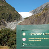 |
| Franz Josef Glacier |
Holly & I hike up the Franz Josef river bed so that we could touch the glacier. It was a fun hike that took about an hour. Holly had been telling me throughout the day that glacier rivers could be identified by the grey color of the water and sure enough the water is grey and really cold! We bouldered along the river bed, climbed up a waterfall (this was a little adlib, but it got us to where we wanted to go). There are lots of waterfalls all along the way to the glacier.
We had just arrived at the glacier where we could see the river coming out from underneath the ice, when you could start to hear the ice creak, I just got my movie camera taking movies in time to see a huge chuck of glacier break away crash on to the ground, we were about 100 yards away, but it was really way cool!
We spent the night in the village of Franz Josef and hiked around a small lake, Lake Matheson, before nightfall. The view of the mountain from the lake was really great, which was a great reflecting pool.
The next morning we hiked up to Fox Glacier, it was a wonderful hike thru the woods to a place were there had been a chalet in the 30's used to view the glacier (which was much larger then), it is just so fun to be able to do these hikes and see these wonderful sites and hear the birdsong and etc, etc, etc
Next up heading to the fiordlands via ?
View Larger Map
Hokitika
Back in the land of lame internet connectivity, so no pics:(
We left Totaranui and headed towards the West Coast to find out what things we could find to explore there. Our first night was in Hokitika, though we were fairly tired by the time we arrived we did get some laundry done, we stayed at a holiday park in a room with a simple kitchen, and shared bathrooms, large kitchen, and laundry. We went to a local restaurant & bar to eat and listen to an open mike session. It's funny that almost all the songs that were sung were released by American artists. Holly had Wild Boar stew which wasn't bad, there seems to be a lot of pork on the menus around New Zealand, there has been evidence of wild pigs on some of our hikes, up on the Separation Point trail in Totaranui there was some significant rooting around the trail.
Hokitika also had a really nice town center that we visited on our way out the next morning. This area has a lot of Jade and there were many shops with Maori carvings made out of jade, my new necklace (which is a traditional Maori fishhook design) is jade and it is really nice. The fishhook design, Hei-Matau, is a sign of respect for the sea and its creatures, it is also regarded a good luck charm providing protection and safety while traveling over water. It goes well with the sea turtle tattoo.
Next up are a couple of glaciers, Franz Josef and Fox Glaciers, that are very close to Mt. Cook.
View Larger Map
Sunday, April 19, 2009
Seperation Point in Totarunui
We did a day hike of about six hours (to & from) to see how our bodies were going to work of long hikes. This hike was label easy (or at least moderate), hmmmmm! We have decided that the multiday full-pack, where we would be packing in tent and bags, is probably not something we are going to be able to do:(, especially on a more difficult trail. Don't get me wrong, we will do plenty of hiking, but just days hikes like this one from a base camp.
We did see so much, dolphins, Pukeko (cool birds), seals, and a birds we have not identified yet. The flora is just fabulous as well and the beaches are to die for. Holly went swimming at the same time we saw the dolphins though they did not come in to swim with her. Later in the day we came across a guy from Germany that we had seen on that beach and he said they did come in very close when he was swimming, he was very excited about this, and I don't blame him.
The hike was really great and it did wear us out, but it is a great way to get worn out.
So, we are heading further south now, towards glaciers and other adventures.
I feel that these posts tonight are lightening fast updates and that I am leaving out so much, because I am, we'll just have to talk about this stuff face-to-face;)
 |
| Totaranui - Seperation Point |
Totaranui - Abel Tasmen National Forest
Continuing is our blazing adventure through New Zealand we left Cowshed falls and headed to our Totaranui campsite in the Able Tasmen National Forest, this country is like 50% national forest, it's really amazing, a great place for outdoor activities, such as hiking or tramping.
These roads were no different twisting and turning, up and down, I was glad I was driving, because I would have been car sick I am sure. Holly was a trooper letting me drive, it gave her knee a chance to feel better. We were so lucky, at the top of this one saddle (pass thru the mountains) we had stopped and I had mentioned that we needed to get the left tire filled with air (something I had noticed a couple of days before). We made it down the mountain to Takaka with no issues, except that we did it on a flat tire. When we were filling up with gas in Takaka I looked at the tire and it was flat and shredded, luckily the station we pulled into was a Firestone dealer, whalah, problem solved in 30 minutes and on to Totaranui.
View Larger Map
We camped at Totaranui for two nights, learning all about sand flies, they are pretty pesty. We have fun camping and enjoying the night skies and sunrises and sunsets and combing the beaches.
Here are some of the sunrises from Totaranui.
These roads were no different twisting and turning, up and down, I was glad I was driving, because I would have been car sick I am sure. Holly was a trooper letting me drive, it gave her knee a chance to feel better. We were so lucky, at the top of this one saddle (pass thru the mountains) we had stopped and I had mentioned that we needed to get the left tire filled with air (something I had noticed a couple of days before). We made it down the mountain to Takaka with no issues, except that we did it on a flat tire. When we were filling up with gas in Takaka I looked at the tire and it was flat and shredded, luckily the station we pulled into was a Firestone dealer, whalah, problem solved in 30 minutes and on to Totaranui.
View Larger Map
We camped at Totaranui for two nights, learning all about sand flies, they are pretty pesty. We have fun camping and enjoying the night skies and sunrises and sunsets and combing the beaches.
 |
| Totaranui Camp |
Here are some of the sunrises from Totaranui.
 |
| Totaranui Sunrises |
Cowshed Bay
We hit the South Island at Picton and headed toward northern west coast. We made it to Cowshed Bay.
View Larger Map
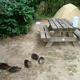
We camped for the night and had ducks for dinner guest and a new friend, the Weka, a flightless bird that is all brown and very friendly.
The roads are so winding, turning, that it makes you head spin. Holly & I have been sharing the driving, this means that we are each getting used to the others driving characteristics or we close our eyes and say everything is fine. The roads are made for motorcycle riding for sure.
View Larger Map
We camped for the night and had ducks for dinner guest and a new friend, the Weka, a flightless bird that is all brown and very friendly.
 |
| Cowshed Bay Camp |
The roads are so winding, turning, that it makes you head spin. Holly & I have been sharing the driving, this means that we are each getting used to the others driving characteristics or we close our eyes and say everything is fine. The roads are made for motorcycle riding for sure.
|
| Cowshed Bay Camp |
Wellington
We headed to the south end of the North Island, to Wellington, after a wonderful night in Dawson Falls.
View Larger Map
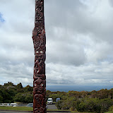
We spent a couple of nights in the Wellington area, in Hutt Valley. This gave us time to go in to Wellington for a day of sight seeing. We spent our day in the New Zealand Museum where we were most interested in the Maori exhibit, to learn about some of the history of this residence, the are descendants Polynesian culture and have been inhabitants of New Zealand since about the 1200's. There were several tribes that migrated to different parts of the New Zealand Islands. Their art is fascinating and I am sporting a new necklace that Holly got me for my birthday that is of Maori design.
We also spent several hours at the Wellington Botanic Garden before headed back to our room at the Holiday Park, we don't camp out every night.
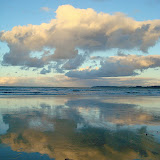
The next morning we had to catch a ferry from Wellington over to Picton on the South Island. Of course, since it was early morning when we got to the ferry, there was time form pictures of the sunrise. Sunrise and Sunset pics are becoming a trademark picture for me.
View Larger Map
We spent a couple of nights in the Wellington area, in Hutt Valley. This gave us time to go in to Wellington for a day of sight seeing. We spent our day in the New Zealand Museum where we were most interested in the Maori exhibit, to learn about some of the history of this residence, the are descendants Polynesian culture and have been inhabitants of New Zealand since about the 1200's. There were several tribes that migrated to different parts of the New Zealand Islands. Their art is fascinating and I am sporting a new necklace that Holly got me for my birthday that is of Maori design.
We also spent several hours at the Wellington Botanic Garden before headed back to our room at the Holiday Park, we don't camp out every night.
 |
| Wellington |
The next morning we had to catch a ferry from Wellington over to Picton on the South Island. Of course, since it was early morning when we got to the ferry, there was time form pictures of the sunrise. Sunrise and Sunset pics are becoming a trademark picture for me.
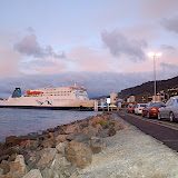 |
| Picton Ferry from Wellington |
Dawson Falls
In my previous post I talked about Dawson Falls, the hike back to a hut etc.
Here are some pics of that part of our adventure.
Here are some pics of that part of our adventure.
 |
| Dawson Falls on Taranaki |
Wednesday, April 15, 2009
Mt. Taranaki
Finally, I have been able to upload some pics to share with you.
I will see how much I work I can't get done on my blog while I have this connection.
I have been trying to get pictures to upload since last night and I have finally given up, you'll just have to read this short entry. Here's what it looks like from above (HINT: on the map press the "-" button several times to zoom out. I have not figured out how get the proper zoom in Google Maps yet).
View Larger Map
Looks like a volcano, because it is a volcano.
So we hike up to one of the huts where you can stay for the night. We hiked from Dawson Falls to the Wang???????? Hut. It was the first hike for me with a full backpack, which was only the two sleeping bags and a few other things, Holly was responsible for carrying all the food. We needed to see if our old bodies would be able to carry this stuff without falling apart and I think that we did fine, even if the hike was less than two hours to the hut. The trail was very much a forest with quite a bit of elevation change. You could never see too much of anything except the trail you are on and you certainly could not see the volcanic peak, but it was really fabulous. So many types of ferns and pine trees and moss hanging off all the trees and little hobbit holes and all sorts of flora that I just don't know what all the plants were. The trails were not too busy, but we did pass several folks that were doing day hikes.
The hut was really nice and it had a great view of the mountain when it was not covered in clouds. The hut has a nice porch, a common area with a kitchen and heating stove and two bedrooms with bunk beds that could sleep 14 people. Once you get to the hut, there is not a lot to do except to enjoy the peaceful serenity of the mountain. We did share the hut with a couple that came in after we got there, we thought that we might have the place to ourselves for a while.
We got there early enough that we read and played cards and then took a hike further down the trail, this included a small one-person at a time bridge over a gorge with a small creek below, you are about 50 feet above the creek that is covered with all the flora I mentioned above. We just kept walking because you were never sure what was around the next turn in the trail, we made it back to the hut just a sunlight was fading.
I was able to get some pictures of the sunrise and a rainbow, it was difficult to get a good picture of the peak through the clouds, but I did get a couple.
We headed back to the car and then drove to Wellington.
Next stop the South Island, yeehaw!
I will see how much I work I can't get done on my blog while I have this connection.
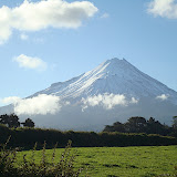 |
| Mt. Taranaki |
I have been trying to get pictures to upload since last night and I have finally given up, you'll just have to read this short entry. Here's what it looks like from above (HINT: on the map press the "-" button several times to zoom out. I have not figured out how get the proper zoom in Google Maps yet).
View Larger Map
Looks like a volcano, because it is a volcano.
So we hike up to one of the huts where you can stay for the night. We hiked from Dawson Falls to the Wang???????? Hut. It was the first hike for me with a full backpack, which was only the two sleeping bags and a few other things, Holly was responsible for carrying all the food. We needed to see if our old bodies would be able to carry this stuff without falling apart and I think that we did fine, even if the hike was less than two hours to the hut. The trail was very much a forest with quite a bit of elevation change. You could never see too much of anything except the trail you are on and you certainly could not see the volcanic peak, but it was really fabulous. So many types of ferns and pine trees and moss hanging off all the trees and little hobbit holes and all sorts of flora that I just don't know what all the plants were. The trails were not too busy, but we did pass several folks that were doing day hikes.
The hut was really nice and it had a great view of the mountain when it was not covered in clouds. The hut has a nice porch, a common area with a kitchen and heating stove and two bedrooms with bunk beds that could sleep 14 people. Once you get to the hut, there is not a lot to do except to enjoy the peaceful serenity of the mountain. We did share the hut with a couple that came in after we got there, we thought that we might have the place to ourselves for a while.
We got there early enough that we read and played cards and then took a hike further down the trail, this included a small one-person at a time bridge over a gorge with a small creek below, you are about 50 feet above the creek that is covered with all the flora I mentioned above. We just kept walking because you were never sure what was around the next turn in the trail, we made it back to the hut just a sunlight was fading.
I was able to get some pictures of the sunrise and a rainbow, it was difficult to get a good picture of the peak through the clouds, but I did get a couple.
We headed back to the car and then drove to Wellington.
Next stop the South Island, yeehaw!
Friday, April 10, 2009
Ohakune
Not all of the places we have spent the nights have been that good, some of this is due to lack of planning on our part, which has also provided some of the spontaneity to our adventure thru New Zealand. When we did not camp at Lake Waikaremoana we drove on to a town of Taupo on Lake Taupo, hmmm!, this town was very touristy and we hit it on Good Friday, yikes (at least from our perspective). We found accommodations, but were up on the road to Ohakune fairly early. We had decided that we did not want to drive all day, which is what we have been doing most of the trip. The drive from Taupo to Ohakune was a two hour drive!, yaahooo! The drive took us past several volcanoes (still active) in the Tongariro National Park and then we landed in Ohakune. Ohakune is a ski-resort area, but since this is the beginning of fall there is no skiing at the moment and this makes it a nice sleepy little village, perfect for a couple of days of relaxation and to enjoy our time celebrating my 50th birthday! Yeehaw. We got a small 2 hour hike in yesterday and will try to get out for another if we can manage our time.
 |
| Ohakune |
Camping, well maybe not yet
When we left the cabin in Tikitiki, we were planning on camping at Lake Waikaremoana, but once we got there it was raining with no campsites that had any type of cover. The temperature was about +5C (40F) and wet and I was a weenie and really did not want to setup and sleep in a wet tent and sleeping bag.
Holly drove most of the way, the road on by Lake Waikaremoana was mainly dirt roads, that took us up and down and up and down along the lake line. There were a couple of nice waterfalls that we stopped and looked at in the rain.
Holly drove most of the way, the road on by Lake Waikaremoana was mainly dirt roads, that took us up and down and up and down along the lake line. There were a couple of nice waterfalls that we stopped and looked at in the rain.
 |
| Lake Waikaremoana |
East Cape & Tikitiki
Yes, we have been driving like crazy on the North Island, trying to see as much as possible in a short amount of time and this is starting to wear us out, we are continually telling ourselves to slow down and listen to the birds and enjoy the sights and not too be is such a rush. One of the fun things is finding places to sleep, either in a campsite or finding a cabin somewhere along the way.
From Cape Rienga in the north to East Cape (in the east, though to figure out I'm sure); East Cape is the most easterly point in New Zealand. When I was planning this trip in my head, I was thinking that I would get some pictures of the sunrise from the lighthouse on East Cape, well after driving 20km on twisting dirt roads and climbing 700+ steps up to the lighthouse, I knew this was not going to happen. But, we did get a great view of the Pacific from the lighthouse the afternoon we past thru.
We headed to a small village called Tikitiki, which had an Anglican Church built with Maori designs in all of the the features. The original church was built in 1880, but burned down, it was rebuilt in 1927 on a new location with help from many of the local artisans.
We stayed at a small backpacker lodge that had several cabins, it was a really nice place close to the beach. I was able to walk out to the beach in the morning and try to catch the sunrise, though it was cloudy enough to prevent the absolute sunrise from being seen it was still really nice and peaceful. The surf on this coast is very turbulent, with tremendous undertow, not a place to go swimming.
 |
| East Cape & Tikitiki |
Waipoua Kauri Forest
When we left our campsite near Cape Reinga, we headed south and we were on a mission to see the Waipoua Kauri Forest and get all the way thru to the south of Auckland, this was not going to be a short day. But we did find time to enjoy the journey thru the forest with it's twisting and turning roads. New Zealand is made for touring on a motorcycle, every road that we have traveled is full of twisties with absolutely gorgeous views.
The Kauri Tree is a old growth tree that can be very large, maybe not as tall as some Redwoods or Sequoia that I have seen but certainly as large in diameter as many, as you can see in the photos I am a tree hugger.
The Kauri Tree is a old growth tree that can be very large, maybe not as tall as some Redwoods or Sequoia that I have seen but certainly as large in diameter as many, as you can see in the photos I am a tree hugger.
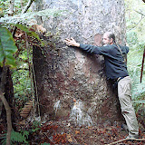 |
| Kauri Forest |
Cape Reinga
After we left Orewa we headed north towards Cape Reinga, though it took us a couple of days to get there (we did have to stop and look at Glow Worms along the way). Cape Reinga is the Northern most point in New Zealand as well as the Western most point on the North Island. Once we got to the Cape, we did a small hike out to the lighthouse. From the Cape you can see where the Tasmen Sea and the Pacific Ocean meet, you can actually see the two currents meeting, it was pretty cool. The picture of Holly pointing in two directions, her right hand is pointing toward the Tasmen Sea and her left towards the Pacific.
We did another small hike out towards the beach that is sacred to the Maori, since it is sacred land we did not trespass but got as close as we could.
We did another small hike out towards the beach that is sacred to the Maori, since it is sacred land we did not trespass but got as close as we could.
 |
| Cape Reinga |
Sunday, April 5, 2009
So this is New Zealand, wow, wow, wow
Well we did make it to the land of the Maori & Kiwi. This is going to be a short blog, but I did want all to know that we have made it and are migrating north. It's a slower migration that we thought it would be, there is just so much beauty every where, wow wow wow.
All the folks here have been so nice; the lady at the car rental that was just too nice to be mad at even though they were an hour late picking us up and the fact that the car rental place was easily in walking distance or the lady that Holly bought a couple of used books from that gave Holly a nice hat when Holly mentioned she was needed to purchase a hat, things like this. Oh, yea I'm on a time limit.
We spent the first day & night in Orewa. A really nice spot. I will write more later. OK, I can write a little more about Orewa now. There was not a great deal to explore here, but it is a very nice landing place, a great place to catch your breath after flying all night from the US. I had no real difficulty driving on the other side of the vehicle going the other way on the roads and Holly was the best navigator, so that all has been going well, e.g. no wrecks yet. I am glad that we landed in Orewa, but we were both looking forward to getting on the road the next day and we did after a nice relaxing day & night. We shopped at the market on Sunday and got enough foods for a couple of days. The US security took our MSR gas tanks we need for our camping stoves, they were empty but had been used (my mistake telling them they had been used, damn that honesty). So, it will be uncooked foods until we get that figured out.
We camped at a nice place (the people running the place come to Austin every year to ride motorcycles, too funny, but why leave NZ the cycling is fabulous) in the Bay of Islands.
On the way we went to visit a cave with glow worms, too fun. We were down in the cave with a young family with 3 kids, they had a brilliant adventure, in the mud and water, and the glow worms looked like stars in the night sky.
Glow Worm Cave
All the folks here have been so nice; the lady at the car rental that was just too nice to be mad at even though they were an hour late picking us up and the fact that the car rental place was easily in walking distance or the lady that Holly bought a couple of used books from that gave Holly a nice hat when Holly mentioned she was needed to purchase a hat, things like this. Oh, yea I'm on a time limit.
We spent the first day & night in Orewa. A really nice spot. I will write more later. OK, I can write a little more about Orewa now. There was not a great deal to explore here, but it is a very nice landing place, a great place to catch your breath after flying all night from the US. I had no real difficulty driving on the other side of the vehicle going the other way on the roads and Holly was the best navigator, so that all has been going well, e.g. no wrecks yet. I am glad that we landed in Orewa, but we were both looking forward to getting on the road the next day and we did after a nice relaxing day & night. We shopped at the market on Sunday and got enough foods for a couple of days. The US security took our MSR gas tanks we need for our camping stoves, they were empty but had been used (my mistake telling them they had been used, damn that honesty). So, it will be uncooked foods until we get that figured out.
 |
| Orewa |
We camped at a nice place (the people running the place come to Austin every year to ride motorcycles, too funny, but why leave NZ the cycling is fabulous) in the Bay of Islands.
On the way we went to visit a cave with glow worms, too fun. We were down in the cave with a young family with 3 kids, they had a brilliant adventure, in the mud and water, and the glow worms looked like stars in the night sky.
Glow Worm Cave
 |
| Glow Worm Cav |
Subscribe to:
Posts (Atom)